Description of the Rivers and Streams
in the Salmon River, NY Area
Below are descriptions of the Salmon River and other streams in the region. These descriptions should be read in conjunction with the Maps provided on this site, which also depict the streams and access points.
For a description of fishing methods and techniques, and a history and background of the Salmon River, please see our Stream Fishing page.
The Salmon River
The Estuary

The Salmon River flows into a large, still estuary before it empties into Lake Ontario. In many areas the estuary is a series of weedy braids. Fishing in the estuary is still fishing with minimal flow. Most fishing in the estuary is done by small
boats.
You can access the estuary from the north entrance to Selkirk Shores State Park at Pine Grove just south of the river off Route 3. From here you will find a dirt launch site for hand-launching small boats. There is a day use fee for launching from
this site while the park is open. The estuary area can also be accessed from the Lighthouse Marina at the end of the road (Route 5) on the north side of the river.
The Douglaston Salmon Run
The The Douglaston Salmon Run, known as the old "DSR", is a private paid-access fishing area that covers approximately 2½ miles, or 25,000 feet of the river from the estuary to just west of Pulaski. The fee to fish in the DSR, from
August through April, is $50 per person. In May through July, fishing is open only to their lodge renters. A limited number of season passes are available on a lottery basis. The DSR limits access to 350 anglers per day on a first-come, first-served
basis. During the peak of the salmon run, the permits may sell out in the morning. Permits can be purchased after noon on the day before. The gate to the DSR, where access is provided and where permits can be obtained, is located on the north
side of Lake Street (County Route 5), about two miles west of the Village of Pulaski. The DSR can be reached by telephone at 315.298.6672. Conditions at the DSR are available at their website at www.douglastonsalmonrun.com.
The DSR imposes regulations in addition to all the New York State regulations. Check with the DSR for details. Significant additional regulations include catch and release only for trout (i.e., steelhead and brown trout) and atlantic salmon, and the
need for river cleats after November 1.
Many consider the DSR some of the finest fishing waters on the river. This area does see the freshest fish, which have just entered the river and passed through the estuary and have seen minimal river fishing pressure. Many local river guides take
their clients to the DSR and provide passes as part of their guide package.
The DSR area has a number of named areas. Beginning from the west near the estuary, the first area is known as the Lower Clay Hole. This is the area where the waterway transitions from an estuary to a river. Proceeding upstream the named areas are
Meadow Run, Clay Hole, Spring Hole, Joss Hole, The Flats, Wall Hole, Sycamore Hole, The Glide, Little Black Hole, Black Hole and Coho Hole. A map of the DSR area is provided on our Maps page.
The areas within the DSR can be accessed only from the north side of the river from the one parking lot and access area maintained by the DSR. There are two sets of steps in the DSR. The set straight south of the parking lot will take you down to
the area just upstream of the Wall Hole. The steps to the west take you down trails and eventually to about the Joss Hole. There is no access from the south side of the river in this area. Some of the named areas of the DSR are only partially
on DSR property and the north sides of these regions can be accessed without a DSR permit. The most notable area which is partially within the DSR area and partially outside the DSR is the Black Hole.
The Pulaski Area
The first major pool which is accessible outside the DSR is the Black Hole. It is just west of Pulaski and just below the sewer treatment plant. The south side of the pool, which is on DSR property, is a high and inaccessible cliff. This is a large
and long pool at a bend in the river.
To access the Black Hole, go west out of Pulaski on Bridge Street. At the bend in the road, turn on the access road to the Municipal garage. In early 2000, the parking lot past the garage was closed due to construction but you could follow the access
road to the sewer plant and park there. There is a path that takes you down the cliff to the pool.
The next pool upriver and within the Village of Pulaski is called the Long Bridge Pool or the Staircase Pool. The Long Bridge is the bridge on South Jefferson Street (a.k.a. Route 11) which passes over the river. To access this pool, turn off South
Jefferson Street just north of the bridge onto James Street. At the end of James Street, turn left onto Forest Drive and you will see the parking area. This is a small parking lot and may be full in peak times of the year. There is also a high
bank on the south side of this pool.

Right in the center of Pulaski is the Short Bridge Pool or the Town Pool. This is the pool which extends upstream from the shorter bridge on Salina Street (a.k.a. Route 11). This pool begins under the bridge and ends upstream beyond the end of the
wall. It is a deep pool which often holds many fish. Because of its ease of access it can be very crowded during the salmon run. Watching people standing on the wall many feet above the water who try to walk along the wall, past many other anglers,
down the rocks and to the river to attempt to land a salmon is quite a spectacle.
There is no public parking lot specifically for the Town Pool. However, there is a free public parking lot on Maple Avenue (a.k.a. Route 2) in town just east of North Jefferson Street. There is a gazebo and steps which lead down to the river. This
will put you on the north side of the river just upstream from the Town Pool. Sometimes you can also park on the street in town.
Still in Pulaski is the Dunbar Field pool or Ball Field pool. This area can be accessed from two directions. From Route 13, turn north on the road (which looks like the driveway) which is just west of Deaton's Hardware Store (and Deaton's
is just west of the railroad tracks). Follow the road around past the hardware store and you will find parking. You can also access this area by traveling east on Lewis Street. Lewis Street begins just east of the Short Bridge. Follow Lewis Street
to its end and you will find a large parking lot.
The last major access point within Pulaski, and which is almost directly north of Dunbar Field, is the area known as the Haldane Community Center area. This large parking area is located just before the Haldane Community Center and the ball field.
It is accessed by turning off Maple Avenue (a.k.a. Route 2) onto Maple Avenue Extension. The lot is located a short distance on the extension. It is across from Haldane Run, a tributary to the Salmon River.
Areas Between Pulaski and Altmar
There is some fishing in the area under the Interstate 81 bridge outside of Pulaski. Most anglers access this area from various business parking lots on Route 13 west of the Interstate.
The first named pools east of Pulaski are the two pools located near the railroad tracks and the Scholler Paper Company. The pool downstream and to the west is the Railroad Bridge pool, and just upstream of it is the Papermill Pool. There is no state
parking lot specifically for these pools. However, there is parking in a rough dirt lot on County Route 2A just west of the railroad tracks. Walk along the tracks on the side closest to the paper company. You will find a path down to the river
just before the bridge. The Railroad Bridge pool is just downstream from the railroad bridge. The Papermill Pool is just upstream from the bridge just before the river bends. It is best approached from the north side, since there is a cliff on
the south side.

The Compactor Pool is the first pool out of town with a dedicated parking lot for anglers. It is located right where County Route 2A passes over the river. There is a large paved parking lot off Route 2A on the north side of the river. Drift boats
often pull out at this location.
The next pool upstream is the popular Sportsman's Pool. This pool can be accessed from public parking lots on either the north side or the south side of the river. The southern parking lot is located on County Route 13. The northern parking lot
is located on Centerville Road. Access to the river is much easier from the southern parking lot. If you park in the parking lot on Centerville Road, it is a long walk down the trail to the river. In low flow conditions, you may be able to cross
the river upstream of the pool.
The Sportsman's pool is very popular and is a relatively large pool. There is also good fishing upstream in the riffles and pocket waters. The Glass Hole is located downstream from the Sportsman's Pool.
The next major access point is at the Pineville Pool. This pool is located where County Route 48 passes over the river. There is parking in a large lot on Sheepskin Road which is off Route 48 just north of the river. Many drift boats launch from this
parking area. Upstream from Pineville is the Refrigerator Pool.

The next major access area is for the Trestle Pool, which is near where Orwell Brook empties into the river. There are parking lots on both the north and south sides of the river for the Trestle Pool. The northern lot is located off Sheepskin Road.
There is a dirt access road off Sheepskin Road which you follow back to a dirt parking lot. The southern lot is a paved lot located on County Route 3. At the end of the southern lot follow the old railroad grade to the end, and paths lead down
to the river. This pool gets its name from the abandoned railroad trestle, the remnants of which still span the river. The pool begins at the old trestle and runs downstream. It is large and deep. This area can also be very crowded during the
salmon season.
Proceeding upstream the next major area is known as Ellis Cove. This area is accessed from County Route 52 on the north side of the river in Altmar. There is a paved parking lot on Route 52 which provides easy access to the river.
Up river from Ellis Cove and just down river from the School House Pool are the two Wire Holes, named for the cables that runs across the river.
Above the Wire Holes is the School House Pool, which is located in the town of Altmar. This is also a popular area and is the last major pool for spin casters. There are two dirt parking lots which provide access to the School House Pool. One lot
is located on the south side of the river (at the beginning of the fly fishing only section) right at the end of Pulaski Street in Altmar. As you go south on Route 13 past the parking lot for the Trestle Pool, bear left onto Pulaski Street to
its end. This parking lot will be in front of you on Bridge Street. (This is also a lot from which many drift boats launch). From this lot, walk across Bridge Street and along the paths on the south side of the river. The lot on the North side
of the river is also located on Bridge Street (a.k.a. Route 52), but on the west side of the road and on the north side of the river. This lot provides easier access to the north side of the School House Pool. Some people also park along the road
near the intersection of Route 52 and Tarr Hill Road and walk across the field to access this pool.
Fly Fishing, Catch and Release Only Sections
There are two fly fishing only sections on the Salmon River. In these sections you may fish only with a traditional fly reel and rod, and you must use only traditional artificial flies. Both sections are catch and release only - no fish of any kind
may be creeled. See the Regulations page for details.
The fact that no fish can be kept in these sections does tend to result in the attraction of anglers who are more interested in the skill of catching fish than securing their next meal. It can be a pleasant break from what can be fierce intensity
during the salmon season on lower sections of the river.
The lower fly fishing only section begins in Altmar at the County Route 52 bridge and goes upstream 1/4 mile to marked boundary at Beaverdam Brook. As explained above in the description of the School House Pool, there are parking lots on each side
of the river - one upstream from the bridge on one just downstream. The lower fly fishing only section is typically open for fishing from September 15 until May 1 each year.
If you are coming from Pulaski on Route 13, bear to the left before Altmar on Pulaski Street (Old Route 13). Take it to its end at Route 52 (a.k.a. Bridge Street) and you will see the southern parking lot in front of you. The other lot is just north
on Bridge Street and on the other side of the river.

Immediately upstream from the bridge at the beginning of the lower fly fishing section is the Cemetery Pool. This is a deep pool and is an excellent producer. It can be effectively fished from either side.
Upstream of the Cemetery Pool are fast riffles, then a long run which can also be productive. There is a cliff on the southern side of this area. Although the river can be accessed along this side, there is little room to maneuver.
The upper fly fishing only section begins just above the Salmon River Fish Hatchery and ends at the marked boundary at the Lighthouse Hill Reservoir. This section of the river is generally open to fishing only between April 1 and November 30. The
sign states it is closed after November 30 to protect eagles which nest in the area. The upper fly fishing section is 6/10ths of a mile in length. It has a steeper gradient than most places on the river and therefore more fast water. It can also
be productive after April 1 for Brown Trout and Skamania Steelhead.
There is a designated parking lot for the Upper Fly Fishing Section which is located on the north side of Route 22 (a.k.a. Cemetery Road) between the Salmon River Fish Hatchery and the Lower Reservoir.
Other Rivers and Streams
Trout and Orwell Brooks
Trout Brook and Orwell Brook are the two major tributaries to the Salmon River that are frequently fished for salmon and steelhead. Both are considered to provide good spawning habitat. Both are also areas where frequent illegal snagging has occurred.
Because these streams provide good spawning grounds and have been areas of angler abuse, the DEC is considering closing these streams to all fishing during the winter and spring. If you fish these streams, please consider practicing catch and
release and give these fish an opportunity to spawn.
There are no major upstream obstructions on either Trout or Orwell Brook.

Trout Brook enters the Salmon River downstream from Pineville. It is smaller than Orwell Brook but can hold salmon or trout if the flow is sufficient. In years of low flow, there will be few salmon in this stream. In years of high flow, it can hold
good numbers of fish. Trout Brook is not a brushy as Orwell Brook, but it still can be tight fishing in places.
Trout Brook can be accessed from the County Route 48 bridge downstream to its confluence with the Salmon River. The stream is posted just above Route 48 (although sections above this area are not posted). A parking lot was recently installed on Mattison
Road just off and Route 48 just north of the stream and provides easy access to this lower stretch of Trout Brook.
You can also access the Salmon River by parking at the Trout Brook parking lot and walking the trails down to the river. It will put you between the Sportsmen's Pool and the Pineville Pool.
Orwell Brook is the second of the two Salmon River tributary streams that is frequently fished for salmon and steelhead. It provides good spawning ground and holds salmon in the fall and steelhead in the spring.
There is a small designated parking lot for Orwell Brook on Tubbs Road just east of its intersection with Route 52. (Route 52 is known as Bridge Street in Altmar). You may also park on Route 52 just south of its intersection with Tubbs Road, and on
Tubbs Road at the bridge over Orwell Brook. Most anglers fish downstream from the bridge at Tubbs Road.
Many parts of Orwell Brook are thick with brush and negotiating around the stream can be difficult.
Grindstone Creek

Grindstone Creek is another stream fished for salmon and steelhead. Although it is not a tributary to the Salmon River, its confluence with Lake Ontario is just south of the mouth of the Salmon River. Grindstone Creek enters Lake Ontario at the southern
edge of Selkirk Shores State Park, and the estuary of the Salmon River borders the north side of the Park.
Grindstone Creek is much smaller than the Salmon River and is slightly larger than Trout and Orwell Brook. Grindstone is stocked with both steelhead and brook trout, and is sometime stocked with chinook. Regardless of its stocking, many salmon and
steelhead find their way into this creek.
The mouth of Grindstone Creek can be accessed from the large parking lot in Selkirk Shores State Park. Follow the main road of the park to the parking lot for the beach area. Grindstone Creek is just south of the parking lot.
There are three state parking lots for upper Grindstone. The first lot is on Route 28. Upstream is a lot on Krebs Road, and upstream from that is a lot on Route 48 before the village of Fernwood. There is a low head dam on the creek in Fernwood which
impedes upstream migration.
Little Sandy Creek
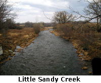
The Little Sandy Creek is north of the Salmon River but still in Oswego County. It flows through the towns of Sandy Creek and Lacona and into North Sandy Pond.
Since there is no upstream dam or reservoir on the Little Sandy, its flow and conditions are much more affected by precipitation levels than the Salmon River. In years of little rain it can be very low and hold few fish. In times of heavy rains it
can be very productive. Although like Grindstone Creek the Little Sandy is not stocked, again many salmon and steelhead find their way into this creek. Little Sandy runs through wooded areas, farm fields, and right through the small towns of Sandy
Creek and Lacona.
There is one designated parking lot for Little Sandy Creek. It is located on Norton Road just off Route 15. There is no easy public access to the creek from this lot upstream to the town of Sandy Creek. However, the stream can be accessed at various
points within the towns of Sandy Creek and Lacona. There is parking available on Main Street in Sandy Creek, and along Academy and Powers Streets in Lacona. Access becomes more difficult east and upstream of Lacona because there is no road which
parallels the creek.
The DEC has acquired public fishing rights on Little Sandy in two locations. The first area begins downstream of the public parking lot on Norton Road, and continues upstream across Norton Road a considerable distance almost to the town of Sandy Creek.
The second area is right in the town of Sandy Creek a short distance downstream and a slightly longer distance upstream of Main Street (U.S. Route 11) in Sandy Creek.
Oswego River
The Oswego River is a very large river which man has tamed with dams and locks. It makes up the Oswego Canal, which is part of the New York State Canal System and is connected to the
Erie Canal. There is a dam above Lock 7 in the City of Oswego which stops all upstream movement of fish. As a result, no salmon or steelhead can pass this barrier and all fishing for these species is confined to the downstream area to the harbor
and mouth. This is primarily an "urban fishery" with the action for salmon and steelhead concentrated within the City of Oswego.
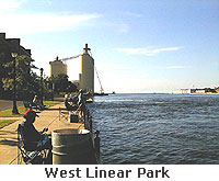
The Oswego Harbor area is wide. Small and large boats fish in the harbor area below the first lock. As the harbor narrows it enters the City below Bridge Street (Route 104). The east and west "Linear Parks" run along each side of the river
from just above the harbor upstream. These are very nice concrete walkways and fishing is permitted along the walks. Bring a long-handled net - the water can be a considerable distance down from the walkway. However, parking in the City can be
problematic, since there are few designated angler parking areas. Boats can launch into this part of the river either from the small public launch located under Bridge Street, or for a fee from Wright's Landing Marina west of the mouth of
the river.
The locks are located on the east side of the river, and consequently the flow is better on the west side. When the locks start, the walkway ends on the east side of the river. The walkway continues upstream on the west side beyond the second upstream
bridge on Utica Street (Route 48). Parking and access to the walkway is available on the west side of the river off First Street above the Utica Street Bridge just south of the Oswego Salmon Shop.
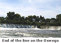
The Oswego gets large runs of salmon in the fall. Since the upstream migration is impeded, the fish - and the anglers - concentrate in a short section of the river. Many anglers fish near the dam. Some access the dam area from the west side above
Utica Street and walk in the river along the power plant. To access the dam area from the east side, travel south on East First Street along the river, and take the first right south of the Utica Street bridge. A sign will say "Lock 7 - Leto
Island." Turn onto this drive, pass over the lock and continue past the lock office and you will be on Leto Island. This island is privately owned and they charge a fee of $5 per day for cars, $10 per day for RVs and $15 per day to park and
launch a boat. From the parking area you can walk down to the river just below the dam.
The Oswego River holds good numbers of salmon in the fall, and steelhead later in the fall through the spring. The walleye fishery in the harbor area, particularly at night, is becoming popular in the spring. Later in the spring and through the summer,
there is good bass and panfish action in the lower part of the river.